

The value of wetlands
Wetlands are areas that are permanently or periodically inundated by water and contain a range of life adapted to being waterlogged. They are the connection between land and water, and offer a range of important ecosystem services as a result.
“Any type of wetland is important for building elevation, so they do sort of guard against sea level rise, which is a huge concern in South Florida. They help filter out nutrients from runoff and water, they sequester carbon, the list goes on,” Sara said.
“They’re vital habitat for a lot of really important species we have in South Florida,” she added.
The wetland Sara studied is located in Cutler Bay, Florida and it had suffered from significant degradation.
“It had just been really overgrown with a lot of invasive species, and it was, I think, previously developed,” Sara said.
“It was a pretty important part of the ecosystem there in Cutler Bay in South Florida. They’re really looking to protect those more like transitional wetlands that are located there. This one in particular was interesting because there’s not a lot of upland wetlands,” she said.
Upland wetlands are the regions of wetlands that are less frequently inundated, and they are often heavily developed. There are currently efforts to try and restore this wetland in Cutler Bay.
“They’re actively doing controlled burns and removing invasive species and doing native plantings there,” Sara said.
All of these factors made it a great case study for Sara to test how drones could help track the progress of the restoration activities
Everglades, Florida
Tracking restoration success through species mapping
Mapping what species occur where is one valuable way of tracking ecosystem restoration progress.
“It’s important because there are several indicator species that can tell different stories about the environment. So one example, I think it was sea ox-eye daisy? It’s a really weedy species and it was all over the more disturbed portion of the site where people were walking. They were doing plantings there and this is one of the first species to establish, because it is more weedy and hardier,” Sara said.
“So tracking species like that can kind of give you an idea of the progress of the restoration. So that’s why species maps are really important. And, of course, for finding invasive species as well,” she said.

Why drones are so helpful
Sara hoped to improve our ability to map wetland species successfully using drones.
“Drones are a really important intermediary between crewed aircraft and ground based remote sensing methods of a field crew going out there and doing a species survey,” she said.
“They can produce very high resolution datasets. So, like on the order of centimetres. This is really important for this site in particular because it was extremely diverse… Even more than that it was a very, very heterogeneous environment, and really benefited from having that high resolution data that you can’t necessarily get from a satellite,” she said.
Although satellite resolution is getting better, satellites pose other problems for wetland species mapping in Florida.
“The issue in South Florida is that we have a lot of cloud cover, and so a lot of satellite data is unusable if there’s too much cloud cover over the site,” Sara said.
“Something like a drone is cheap. You can fly it whenever you want to collect the data. We were using a really cheap system that was under $1000. And it’s on demand, so you can really measure change over time.”
Another big benefit Sara noted drones offer is their ability to produce three dimensional data.
“The three dimensional data, like a canopy height model or a digital elevation model are really important predictive variables in a model to delineate species,” Sara said.
“A lot of these wetland species have very similar spectral signatures, and they wouldn’t necessarily be able to be separated just based on that. So, having variables that indicate the canopy height and the elevation of where the vegetation is existing, help increase the severability between the classes.”
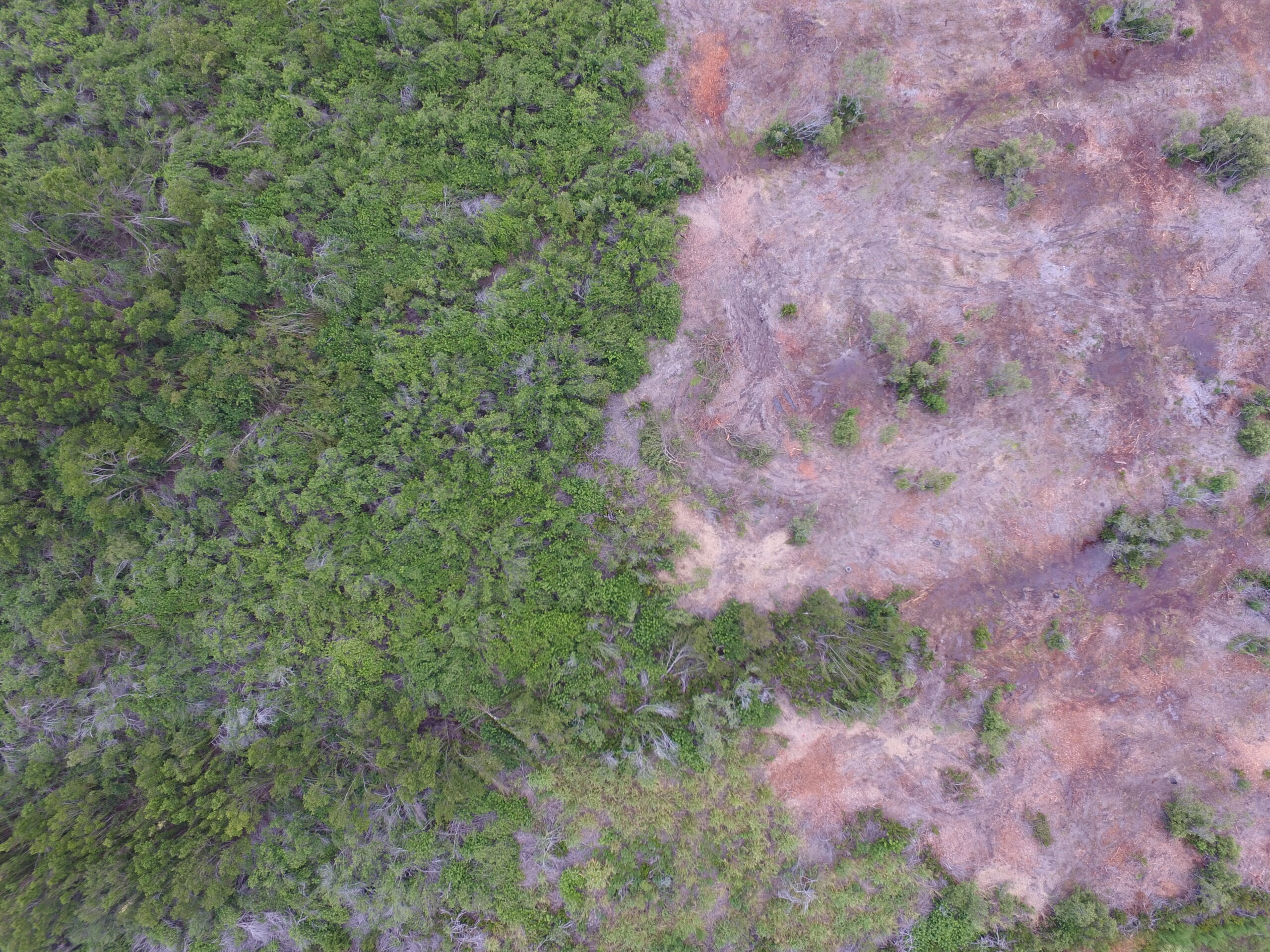
An example of high-resolution imagery of the wetland Sara captured using a drone.
Processing the wetland data with machine learning
Machine learning is the main strategy researchers use to quickly and accurately process the vast quantities of data that drones can collect. It aims to identify features in a picture, based on pre-set classes. In the case of Sara’s research, the classes were different wetland plant species.
“Machine learning is really powerful in remote sensing because it can detect patterns that are too complex for human understanding…it can detect these, like extremely minute trends in a ton of predictive variables,” Sara said.
There are two traditional methods used for machine learning classification: pixel-based classification and object-based image analysis.
Pixel-based image analysis
Pixel-based image analysis, as the name suggests, works by assigning classes to certain pixels based on the pixel qualities. With a standard RGB sensor, this classification is based on the respective red, green, and blue values of each pixel. But Sara says it’s an approach that is not well-suited to wetland species classification.
“You think of an image, you think of pixels as your unit of analysis. But pixels are like an arbitrary unit of measure, right? They could be a mix of different materials, and for drone pixels in particular, because they’re so high resolution, there’s a ton of noise. I mean, we’re talking like centimetre level pixels here. That’s the shadow cast by a leaf,” she said.
This can often cause something called the ‘salt and pepper’ effect. This effect occurs when small variations in the surface reflectance of an object leads to pixels near each other being incorrectly classified as different features.
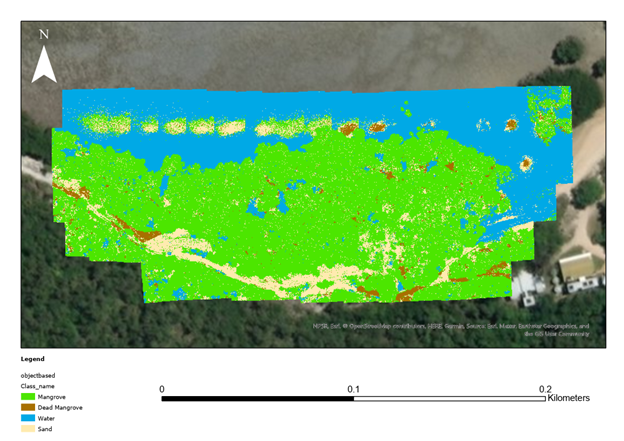
An example of a pixel-based image classification from a mangrove survey on Orpheus Island, Australia. Read more here
Object-based image analysis
Instead of a pixel-based image analysis, Sara used an object-based image analysis (OBIA) approach to map the wetland species.
“Object-based image analysis is a way to group pixels together that are alike to create more meaningful units as input for your classification. So it smooths the data out, it captures more of a community rather than variation between what could just be the same plant.”
An OBIA approach also offers more variables machine learning can use to distinguish different features. The pixel-based approach can only make distinctions based on the pixel values. OBIA can also consider factors like the maximum, minimum, and mean values of the bands within an object.
Using OBIA, Sara and her team could identify 17 species with 71.3% accuracy and ten major species with 84.3% accuracy. This level of accuracy could be very helpful to inform wetland management in the future.
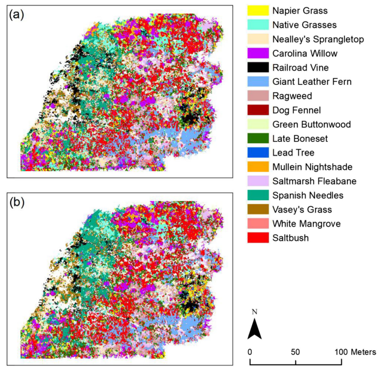
Wetland species classification using object-based image analysis and two different machine learning approaches a) random forest and b) support vector machine. Source: Durgan et al., 2020
Learn more about drones and machine learning
You can read the article Sara published about her research here. Florida wetlands aren’t the only place where drones and machine learning are helping researchers collect data on the natural environment. They’ve also helped monitor oyster reefs, seagrass meadows and to track vegetation recovery after fires.
GeoNadir helps drone pilots from all over the world store, manage and share their drone mapping data. By uploading your datasets, you’re also making sure more people can learn from and use your drone data. Getting started is free!

