
The old saying “a stitch in time saves nine” is pretty apt for environmental monitoring and management. The sooner that we can spot a problem in the environment, the smaller it usually is and the easier it is to fix. When a problem goes unnoticed for a while, it can quickly snowball and become very expensive and complicated to fix. The longer a problem goes unnoticed, often the bigger and trickier it is to solve.
Consistent environmental monitoring and management is the best way to spot and address problems quickly. But in the past, it’s often taken time, money, and technical expertise. That’s made consistent monitoring difficult, especially in environments where fieldwork is challenging. The result is patchy, inconsistent monitoring records, where small problems can go undetected until they are too big to easily fix. Drones offer a way to quickly collect valuable data in challenging environments without the pilot needing a specialist background.
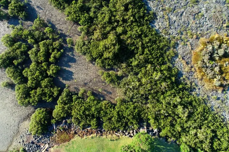
Environmental monitoring and management of oyster reefs
Meola Reef Te Tokoroa. Source: Kavita Prasad
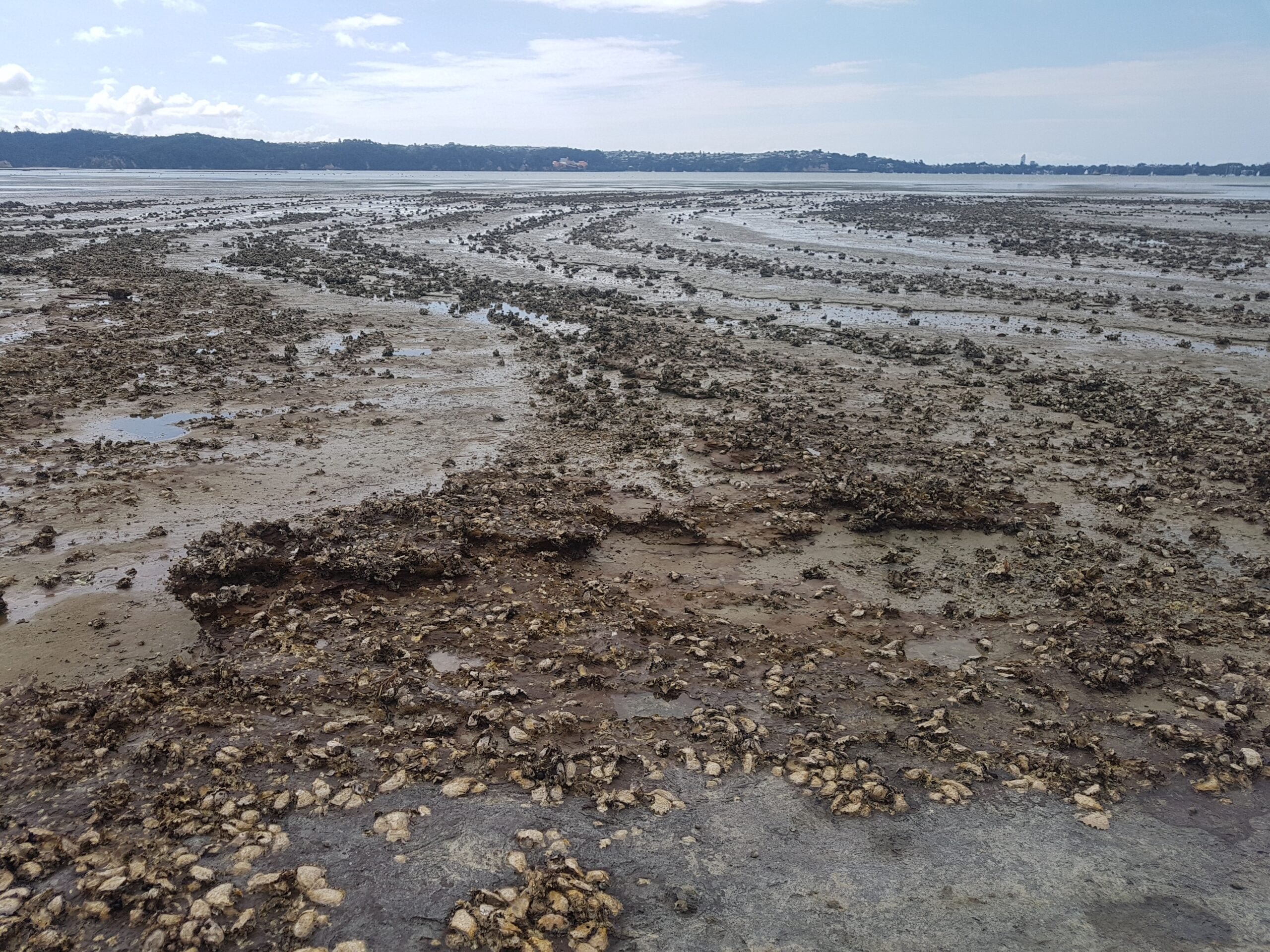
Subhash Chand from Auckland University of Technology has spent his PhD trying to fill these monitoring holes. Subhash’s research has established that drones are the solution for consistent environmental monitoring and management of New Zealand’s oyster reefs. Currently, field measurements are the main method of monitoring oyster reefs. But oyster reefs can be big. Sampling the whole reef would take too much time and personnel. On the other hand, sampling only some locations runs the risk of missing other areas that are having problems. Plus, there’s also only a small window of one to two hours per day where the tide is low enough for fieldwork. Subhash thinks that drones are the solution to allow consistent environmental monitoring and management of New Zealand’s oyster reefs.
Why satellites don’t really work
Oyster reefs are one system that has always been challenging to monitor through traditional remote sensing. Although these reefs can be quite large, the creatures that build them are quite small. Even satellite images that offer 30cm resolution aren’t detailed enough to detect oysters that are only a few centimetres long. At 30cm resolution, every pixel of colour represents a 30cm by 30cm square on the ground. Although there might be oysters in that pixel, there will also often be mud and other material. Since the pixel will only show the average colour of all the objects in that 30cm by 30cm area, the spectral mixing can hide the presence of oysters.
Another challenge with using satellites is timing. Oyster reefs generally occur in intertidal habitats, where the water can be quite cloudy from pollution and soil from rivers. This means that oysters are only visible from satellite imagery at low tide. At high tide, regardless of resolution, the cloudy water completely obscures the reefs. Sometimes, clouds will prevent anything from being seen at all. But you can’t control when a satellite passes over. It’s rare for satellites to take images at low tide, so very little satellite data is actually helpful for monitoring oysters. Although traditional aerial imagery might be useful for one-off monitoring, it’s too expensive to repeat regularly for consistent monitoring.
 Satellite
 Drone
Drone
Why drones are the future of oyster reef environmental monitoring and management
Resolution
Drones can survey a larger area than fieldwork, without the restrictions of resolution and timing of satellite imagery. Using a high-resolution camera and low flight altitude, drone imagery can be a few centimeters in resolution rather than tens of centimeters. That means less spectral mixing, making it easier to identify oysters, even when they are spread out or sparse.
Timing
Because the pilot decides when to fly the drone, they can choose when to capture the data. Data can not only be consistently collected at low tide, but also when conditions are best to see the oysters. For example, flying when water is clearer, or when there’s less sun glint can improve the accuracy of oyster identification. They can also collect a lot more data than fieldwork in the small window for data collection at low tide.

The Phantom 4 Pro drone that Subhash used to map the oyster reef. Source: Kavita Prasad
Beginner friendly and affordable
For monitoring to be consistent, the monitoring methodology has to be fairly straightforward and affordable to do regularly. Aerial imagery and satellite imagery can be costly and often require technical experience to interpret. In contrast, capturing good drone mapping datasets requires minimal training or experience. They’re also cheap to collect since the only cost is purchasing the drone in the first place. There are multiple free automated options for planning drone mapping missions. If you upload your image collection to GeoNadir, we’ll turn your phtoos into an easily interpreted orthomosaic for free! The high resolution of the imagery means that even someone with no remote sensing background can spot changes between mapping missions, like loss of oyster cover. Using drones, anyone with minimal training can achieve the main goal of consistent environmental monitoring and management: spotting problems early. Drones make consistent monitoring much more accessible and achievable.
Lots of useful data
Spotting the problem on an oyster reef can be easily done by someone with little technical background. But if there is a problem, drone images often contain enough information that someone with a technical background can start to do more thorough spatial analyses. For example, a common predator of oysters is a borer snail, and it can cause the dieback of oyster reefs. Evidence of borer snail infestations can actually be visible from high-resolution drone imagery.
Multispectral data captured by drones can also help distinguish more details of the oyster reef, making it easier to determine where to focus management interventions. Rather than wandering around a whole oyster reef in a limited time frame, drone images can identify areas of concern or change that should be the priority for limited fieldwork time and resources.
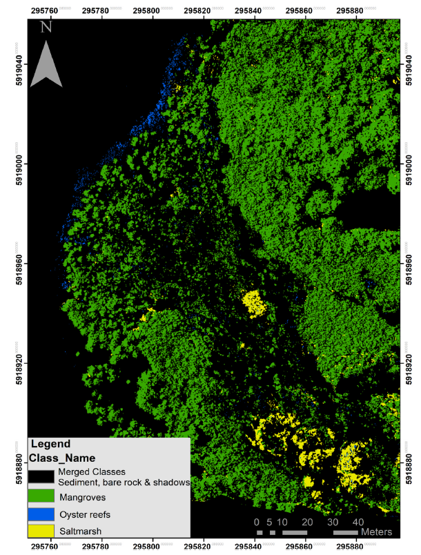
The image to the left shows a classification of intertidal ecosystems of Meola Reef Te Tokoroa from drone imagery using Support Vector Machine classification. Source: Subhash Chand
Want to learn more?
You can look at the many intertidal habitats in New Zealand that Subhash Chand has mapped on GeoNadir, or you can read the article that he published based on his research here.
If you enjoyed this article, you might also like to check out some of our other ones:

