
Most of us are familiar with the concept of 3D. It’s the difference between old school classic cartoons like Tom and Jerry and modern animation like Toy Story. It’s how our brain processes vision from both our eyes to give us depth perception. If our vision left to right is considered as two dimensions, the third dimension helps us perceive the distance away from us.
But what does this have to do with drones? And how can drone 3D models be used to better understand the environment? Let’s find out.
Contents
What is a drone 3D model?
Traditionally, a map is two dimensional, or 2D. It has location information in the x-y plane, derived from latitude and longitude, or some other co-ordinate system. Elevation is the third dimension (3D) – or bathymetry if we’re underwater.
A drone 3D model (also digital elevation model or DEM) is a digital representation of a real-world object, structure, or area created using data captured by a drone. Drones equipped with cameras or specialized sensors can capture aerial imagery and other data, which we process to generate a detailed 3D model. This 3D drone model can provide a realistic and accurate view of the object or terrain, capturing its shape, texture, and spatial relationships.
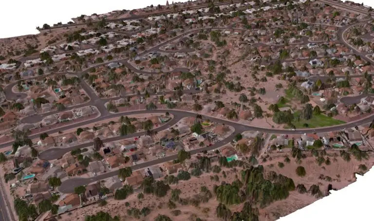
DEMs fall into two groups – digital surface models (DSM) and digital terrain model (DTM). The DSM still contains the trees and houses – as below. Check out the full dataset here.
 Digital terrain model (DTM)
 Digital surface model (DSM)
Our favourite ways to use drone 3D models
There’s no shortage of uses for 3D drone mapping! Here’s some of our favourites.
Terrain analysis: Analyze and understand the terrain including slope, aspect, and elevation changes.
Flood and hydrology studies: Simulate and predict potential flood areas by using the model to identify low-lying areas and drainage patterns.
Urban planning: Determine suitable locations for developing infrastructure or assessing the impact of new buildings on the landscape.
- Minesite rehabilitation: Create precise contour mapping of the terrain before and after mining activities. This helps plan and implement effective rehabilitation strategies.
- Precision farming: Identify variations in elevation, slope, and aspect across fields. This enables variable rate application of fertilizers and irrigation based on terrain characteristics.
- Hiking and outdoor activities: Plan hiking routes and outdoor adventures by analyzing elevation changes and terrain difficulty.
Solar energy potential: Analyze the slope and orientation of the terrain to find optimal locations.
Line of sight analysis: Determine the visibility between different points to assess line-of-sight obstructions such as hills, buildings, or vegetation.
3D Visualization and Virtual Tours: Create visually stunning 3D visualizations or virtual tours by combining the DEM with aerial imagery or satellite data.
Environmental management: Analyze the suitability of habitats for various species by using the DEM to assess factors like elevation, vegetation cover, and slope.

How are drone 3D models created?
To create a 3D drone model, we capture multiple images or scans of the target area from different angles and positions. Each of the ‘views’ needs to overlap each other. This is similar to the way our eyes work. Each eye views the world from a slightly different angle. Our brain processes the information together to create a 3D view in our mind, giving us depth perception of the world around us. This is why those with a single eye vision impairment cannot see in 3D.
Like with our brain, we use specialised software like GeoNadir to process the images. The software uses photogrammetry to stitch them together and create a 3D representation.
Do I need a special drone?
Not really! As long as your drone has a camera that can be pointed at nadir (directly down), you can start to capture the data needed to create a 3D model. Of course it helps if your drone has an app that will allow it to fly autonomously on your mapping mission. And you really do get what you pay for. So if you’re looking to get into serious drone mapping and 3D modelling, it’s worth investing in the right hardware. You can learn more about making an accurate and useful drone map from our blog on that topic.
If you’re looking for more resources to get started capturing data, also check out our free e-book, and online training course.
If you’re ready to get started with drone 3D models, why not create a free account with GeoNadir today? Upload your drone mapping data and we’ll even do the processing for you.

