
Coastal environments are in constant flux, influenced by tides, storms, and human activity. Understanding these changes is critical for managing coastal erosion, assessing storm impacts, and informing conservation efforts. Drone mapping provides a powerful way to track these changes with high spatial accuracy. In no particular order, here are ten ways you can assess beach change using drone data—along with why it matters.
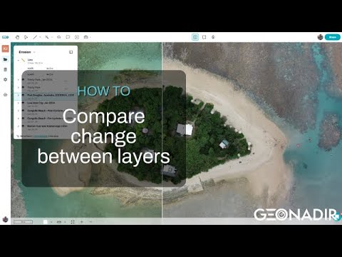
1. Compare before-and-after imagery to spot visual changes
📌 Benefit: Quickly identify erosion, deposition, or infrastructure changes without complex analysis.
Using an interactive swipe tool to compare orthomosaics from different dates allows coastal managers, researchers, and local communities to easily see where sand has moved, vegetation has changed, or infrastructure has been affected by storms.
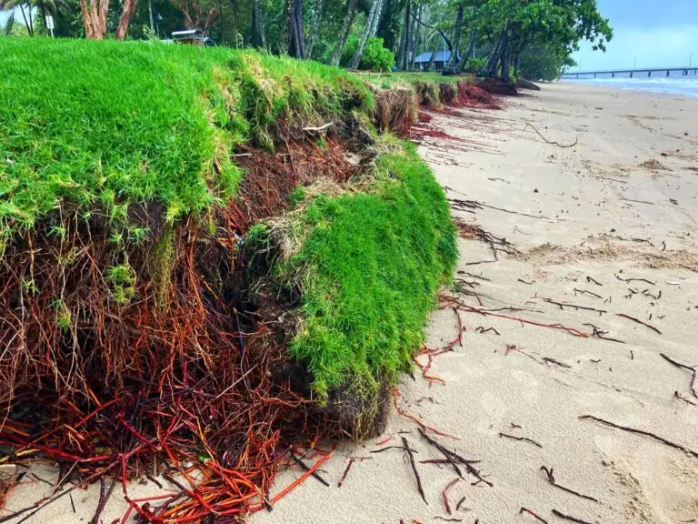
2. Use elevation models to reveal coastal erosion
📌 Benefit: Detect subtle changes in beach elevation that aren’t visible in regular images.
Comparing Digital Surface Models (DSMs) and Digital Terrain Models (DTMs) over time can highlight beach erosion, dune loss, or sediment buildup, even in areas where the surface looks unchanged in regular imagery. Contrast enhancement can further clarify differences.

3. Map changes automatically with AI-assisted detection
📌 Benefit: Save time by letting AI highlight significant changes for you.
Using change detection tools in GeoNadir, you can automatically identify areas of difference between datasets. Whether digitizing by hand or using the Magic Wand tool to auto-select regions of change, this method streamlines coastal monitoring.

4. Analyze terrain profiles to understand beach slopes
📌 Benefit: Assess how storm surges, erosion, or human activity reshape the beach profile.
By extracting terrain profiles from elevation models, you can visualize cross-sections of the beach. This helps determine if dunes are flattening, sand is shifting seaward, or steep erosion scarp formations are appearing.

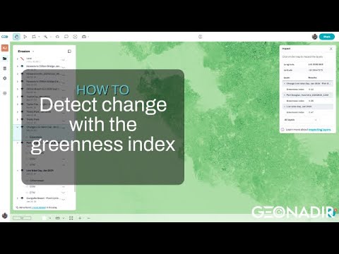
5. Track vegetation shifts to monitor ecosystem health
📌 Benefit: Identify whether dune and coastal vegetation is recovering or degrading.
Using a vegetation index (such as the Greenness Index) in combination with contrast enhancement, you can highlight changes in vegetation cover. This is critical for understanding dune stability, as vegetation loss often leads to increased erosion.
6. Adjust layer transparency to compare changes more clearly
📌 Benefit: Gain a better perspective on coastal evolution by layering multiple datasets.
Overlaying past and present imagery or elevation models and adjusting transparency allows you to visually analyze shifts. This approach is useful for understanding gradual changes over time, such as shoreline retreat or sand dune migration.

7. Combine transparency with AI-based selection to measure coastal erosion
📌 Benefit: Detect, measure, and map changes faster and with greater accuracy.
Using the Magic Wand tool in combination with transparency adjustments allows for automated boundary detection, making it easier to quantify the affected area and generate accurate change maps.

8. Inspect pixel values to quantify elevation and surface changes
📌 Benefit: Get precise numerical differences rather than just visual estimates.
The Inspect Tool lets you check pixel values across layers (e.g., DSM, DTM, and multispectral indices). This is valuable for pinpointing areas with significant elevation loss or deposition—especially when monitoring small but important shifts.

9. Measure volume changes to understand sediment movement
📌 Benefit: Calculate how much sand is lost or gained, essential for erosion control plans.
You can calculate volumes using the DSM or DTM across multiple dates, helping assess how much sand has been washed away or where it has accumulated. This is essential for beach nourishment projects and erosion risk assessments.

10. Detect elevation-based changes with automated analysis
📌 Benefit: Focus on meaningful changes without manually comparing maps pixel by pixel.
The change detection tool on DSM/DTM automates the process of identifying elevation shifts, making it easier to track erosion, dune reshaping, and sediment deposition over time. Make sure that you are using ground control points (GCPs) for optimal results!

Why This Matters
Beach monitoring for coastal erosion isn’t just about collecting data—it’s about making informed decisions that help coastal managers, scientists, and communities adapt to change. With drone mapping and tools like those on GeoNadir, you can detect, measure, and communicate beach changes faster and more effectively than ever before.
But of course it’s always important to recognise that your local beach is just one piece in a gigantic puzzle. So while you may be able to monitor how it changes over time, any intervention must take into account the greater system. Because erosion at one beach can be caused by something happening in an entirely different location! And any intervention made will undoubtedly have an effect in other locations too.

