Earth observation (EO) data are everywhere, just like Swifties. Datasets are growing by over 100 petabytes per year, with a steady expansion in geospatial AI technology driven by new satellites and the democratization of data capture through drones. In fact, there are more drones in circulation today than there are kilometers of coastline worldwide. Despite this, 99% of the world’s EO data remains unanalyzed. It’s like an all-you-can-eat buffet without the cutlery—endless options, but no way to fully dig in.
My 25 years in EO have shown me that while we some of us do have “cutlery,” for many it often feels like we’re dealing with IKEA instructions: convoluted, requiring expert knowledge, and often incomplete. This complexity keeps geospatial analysis in the realm of elite professionals. However, as pressing environmental issues grow, our ability to analyze EO data becomes critical. Relying on just 1% of available data won’t help us tackle biodiversity loss, food security, climate change, or disaster management effectively. We need scalable, collaborative, intuitive tools—ones that don’t just allow experts to work but instead empower everyone to get involved.
Contents
Making geospatial user-friendly
Today’s technology should be as seamless as streaming your favorite show, but geospatial sometimes feels like rewinding VHS tapes—slow, outdated, and frustrating. I experience this every year through the eyes of my university students. More and more I see them as intolerant of the ways that ‘it has always been done’ in geospatial. There has to be better options. So how do we shift from antiquated tools to something intuitive? Enter artificial intelligence (AI), which has become as ubiquitous as avocado on toast.
While AI in EO might sound new to some, the truth is we’ve been doing it for years. Techniques like thresholding and region growing have been around for decades before me, and by the early 2000s, we were already using object-based image analysis and tools like eCognition. Over time, support vector machine, random forest, and convolutional neural networks found their place in geospatial. Yet, despite decades of progress, these tools have often remained locked away, complex and inaccessible—like a prized music catalog waiting to be re-released (have at it Tay Tay!).
AI in geospatial
In the meantime, I feel that other fields have leapfrogged ahead in AI adoption. Graphic design and video editing embraced segmentation for background removal, giving everyone the option to hide their messy lounge or bedroom behind them on Zoom.


MetaAI’s Segment Anything Model (SAM) has further pushed the boundaries, making segmentation as easy as clicking on an object. This model works surprisingly well on drone data, despite largely being trained on non-aerial imagery. It’s fast, intuitive, and efficient. You can see for yourself below with the drone image of a coral reef, how easily it detects individual patches (size dependent). It doesn’t actually know what the segments are though.


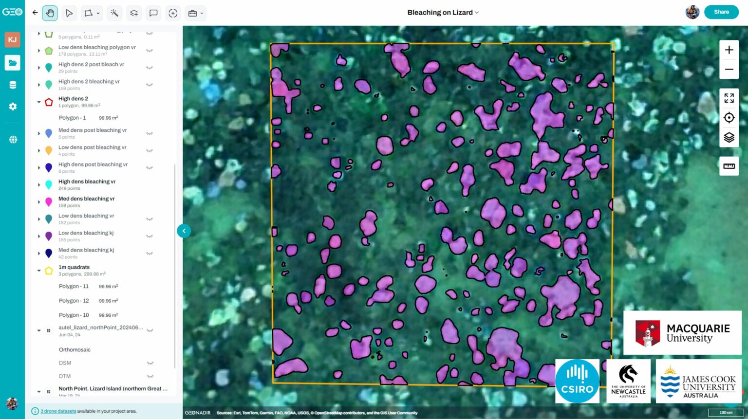
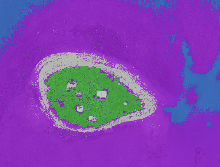
Taking SAM and bringing it back to geospatial AI was a bit of a challenge, but we got there! This means that it’s helpful not just for pretty pictures, but for actually mapping stuff (see right). This ‘zero shot’ approach means that the user doesn’t even have to provide training data, so we can just get in and start analysing.
Pair SAM with large language models, and tools like Grounding DINO now allow us to use simple text prompts to locate features like trees or cars in EO images. These tools are bringing us closer to a reality where geospatial tech is accessible to all, not just experts. Imagine a platform so intuitive that even the most tech-averse person could navigate it, finally tapping into the 99% of EO data left untouched.
Modern online, realtime collaboration
In 2006, Google Docs revolutionized collaboration, allowing people to work on documents together in real time. Since then, tools like Slack, Figma, and Microsoft Office 365 have followed suit. Canva and Notion also offer real-time collaboration, proving that technology has moved on. COVID-19 brought collaborative tools further into the spotlight, pushing platforms like Miro, Soundtrap, Unity, and Blender into various fields.
Yet geospatial remains stuck in the past. When we’re dealing with planetary challenges, we need collaboration tools that let us work at the speed of need. Our field has been left behind, perhaps distracted by the wealth of data but lacking the tools to make it useful.
To unlock the full potential of geospatial AI, we need collaboration. When people work together, our efforts amplify, creating outcomes far greater than if they worked alone. Unfortunately, geospatial still tends to operate like a relay race. Someone does their bit, then passes it on, waiting for their next turn. It’s as if we’re playing “pass the parcel” with shapefiles, emailing them around with versions named “final_v2_final_ABSOLUTELYfinal.” With a few notable but very recent exceptions (e.g. Felt and of course GeoNadir), collaboration in real time is almost nonexistent in geospatial.
It’s been a real highlight of building GeoNadir to focus on community and collaboration instead of silos, and to see the difference that it makes.
Real-time collaboration and geospatial AI in action
In early 2024, we had the opportunity to demonstrate a change in the status quo. When severe coral bleaching impacted reefs worldwide, a team from CSIRO was in Lizard Island’s vicinity and captured drone data on the bleaching extent. But instead of holding the data for an exclusive publication, they uploaded it to GeoNadir’s FAIR global map, making it findable, accessible, interoperable, and reusable. The platform processed the data automatically, creating an orthomosaic available to all.
Seeing this, I collaborated with colleagues from GeoNadir, Macquarie University, and the University of Newcastle, who were heading to the same area. We decided to survey the same region to assess coral mortality. By using GeoNadir, we could upload our data instantly and work together on a shared project—even while the field team was still out at sea. Within days, we analyzed bleaching extent and coral mortality, finding that up to 97% of some coral had died post-bleaching. We shared these findings through media, social channels, and prepared a publication—taking advantage of GeoNadir’s latest AI tools to speed up analysis.
This project worked because the data were open, and the tools allowed us to collaborate in real time without technical barriers. No endless shapefile exchanges or SharePoint struggles, and no local software requirements. By centralizing the data and removing the need for high-powered personal computers, we focused on analyzing and sharing our findings efficiently.

The power of open data with geospatial tools
As more groups contribute data to the FAIR global map, we can track ecosystems we care about and respond swiftly. Today, at least 11 groups contribute data on the Great Barrier Reef, shifting from USBs and hard drives to a centralized, accessible platform. But building better geospatial tools isn’t just about speed—it’s about avoiding waste. Unlike fast food or fast fashion, we’re aiming for thoughtful, sustainable technology, much like Taylor Swift’s re-recording process: making what’s there more accessible, relevant, and ready for the future.
Democratizing geospatial technology goes beyond accessibility; it’s about unlocking potential and empowering innovation. Rather than building tools that require technical “cutlery,” we need experiences that are intuitive and welcoming to all. What if we removed the cutlery altogether? Imagine diving into data freely, without needing specialized training or niche software. The future of geospatial calls for seamless, smart, and sustainable collaboration.
So—are you ready for it?


