
Drone crashes do happen, but there are ways to avoid them. Find out how in this article.
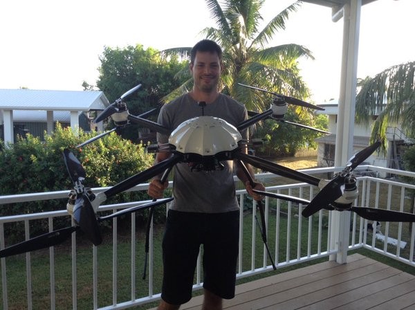
It doesn’t matter if I’m talking to kids or adults, the most common question I’m asked about droning is if I’ve crashed. And while I can’t say that watching a 35kg beast crash is the highlight of my career (manufacturer error, I swear!), I have the following mantra: as long as no one is hurt, you weren’t being silly, and you learn from it, it’s ok.
Granted, I’m usually saying this to students about <100g Tello drones, and it really is ok with those lightweights!
Unfortunately most of the crash incidents we hear about on social media fall into the silly category, and sometimes there’s even some blood involved. For some it appears to be something to laugh about. I don’t get that, and those are not the crashes that I encourage talking about. Though if you want to learn from others’ stupidity, that’s all good too 🙂
We were doing some test flights during a handover from the manufacturer and it was sounding a little odd in the air. Then despite both me and the engineer thoroughly conducting our pre-flight safety checks (yes, this is one learning point – safety checks are critical!), to our horror, one of the propellers spun off mid air with the drone at about 10m altitude.
At that moment we reached our ‘choose your own adventure’ decision point.
- Cut all motors and deploy the parachute, hoping the Gazoo would float softly to the ground, OR
- With seven other motors (the 8th is a redundancy measure), we could try to land.
What would you have done?
Instinct kicked in for the engineer with a tonne more experience than me and he deployed the parachute. The rationale was that given we had already lost one propellor for unknown reasons, he didn’t know if a second one would also malfunction and the drone would plummet regardless.
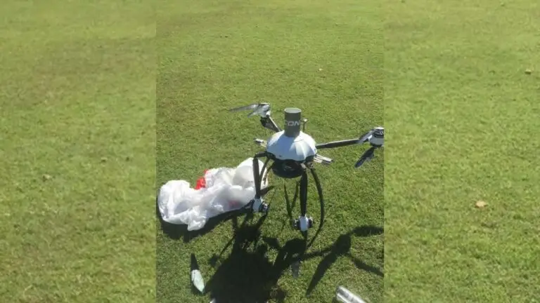
The complicating factor was that the parachute needed time and space to fully deploy, and for this model, it required 20m of fall time. We didn’t have enough for it to fully save the Great Gazoo as you may have guessed from the spoiler header image!
So it was a sad day when the Gazoo broke two arms and a couple of propellers, but thankfully the remainder of the drone was left in good condition. Without the parachute, things would have definitely been a lot worse.
One of my clearest memories from that day, however, is one of the snapped 26″ carbon fibre propellers that I retrieved. It had sliced about 10cm into the extremely hard and dry soil of the playing field. How easily that could have caused a significant injury, potentially leading to an injury compensation claim, if we had not been following safety protocols (and law) of keeping our drone 30m away from people.
I don’t share this story to instill fear of drones, even though I sometimes jokingly refer to them as flying Edward Scissorhands. Drones are just like any machines that need to be treated with respect and a knowledge that accidents can happen. However like any risk mitigating meaure, we need to reduce either the liklihood or consequence of an incident occuring.
So, for my final learning points in regards to sharing this experience. Please keep your drone a safe distance from others, and never fly over the top of people without the appropriate training, qualifications, certifications, redundancies, and other risk mitigating measures.
It’s that simple.
Next time you’re out flying, how about taking an extra battery and using it to help me create the world’s most detailed map possible to help protect Mother Earth‘s at-risk ecosystems? Find out more here: https://www.geonadir.com/drone-pilots
If you’d like to learn more about how you can use your drone for mapping purposes, check out https://education.shemaps.com/dronemapping

