What is the resolution of drone mapping?

Many people use drones for mapping to achieve greater resolution when compared to traditional aerial photography or satellite imagery. But what does ‘resolution’ really mean when considering remotely sensed data? There are actually three main types of resolution relevant here: spatial, spectral, and temporal. Let’s explore each below in the context of drone data collection.

What does spatial resolution mean?

When talking about image resolution, most people are referring to spatial resolution. This is the amount of detail that we can see when zooming in to an image. We often call this the pixel size, though the more correct reference is ground sample distance or GSD.

All digital images are made up of pixels – picture elements – that you can see as coloured squares when zooming all the way into an image. In a drone image, each pixel represents a square of land or sea on the surface of the earth. It’s the size of that ground representation that’s called the GSD, and often referred to as the spatial resolution. With drones, we usually measure this in terms of centimeters per pixel, compared to satellites at meters and sometimes even kilometers per pixel.

Regardless of the drone or satellite platform, the spatial resolution achieved is a function of two things: 

  1. the sensor or camera itself, and 
  2. the distance between the sensor and the ground. 

The characteristics of any given sensor (drone or satellite) are set at manufacture. But we can vary the size of the GSD depending on the flight altitude. For example, when flying a DJI Phantom 4 Pro with its 20MP camera at 120 m altitude, the GSD is about 3.6 cm per pixel. For higher spatial resolution, simply decrease the altitude! Or use a better sensor / platform combination. 

Rather than asking what spatial resolution can you achieve, try considering first asking what spatial resolution does your application need?

drone resolution 50m altitude Mavic Pro
20m altitude Mavic Pro

What is spectral resolution?

Spectral resolution considers the ‘colours’ detected by a sensor or camera. Unimpaired human vision detects three colours – red, green, and blue (RGB). We mix these colours together to perceive the entire rainbow. Each colour represents a collection of wavelengths within the visible portion of the electromagnetic spectrum, and most commercial cameras  are tuned to mimic our RGB sensitivity. This includes drone cameras.

However, human RGB sensitivity is limited and there are many other wavelengths of light that we can’t detect. These invisible light wavelengths can provide us with information about various biogeochemical properties of environmental features – if we can detect them.

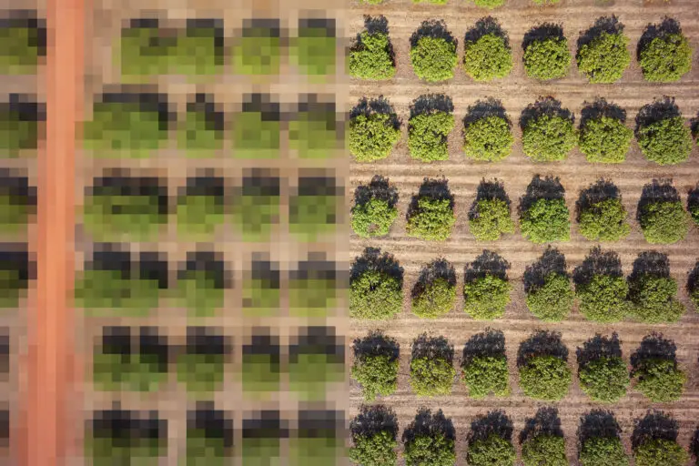
But we can use specialised sensors to detect and measure information in these specific wavelengths. Several off the shelf drones can detect near infrared (NIR) light in addition to RGB, and they’re often used to monitor vegetation health and biomass. With four broad bands (RGBN), these multispectral sensors have a higher spectral resolution than an RGB sensor.

More sophisticated sensors can measure tens to hundreds of wavelengths. These hyperspectral sensors are considered very high spectral resolution. There are currently very few hyperspectral sensors suitable for drones.

multispectral drone imagery of coral
Multispectral drone imagery of coral – live coral appears red

What is temporal resolution?

We often promote drones for their potential to capture data with very high temporal resolution. In other words, they can capture data very frequently. However, while theoretically we can fly at any time of day and as often as we like (weather permitting), we don’t often do this in practice. They certainly provide the flexibility for capturing data in a timely manner, yet they are contingent on the operator availability.

By contrast, satellites routinely capture data at set time intervals. This means that they have a more consistent temporal resolution that often ends up more frequently capturing data in practice as well.

What are the resolution trade offs in drone mapping?

There are always trade offs in remote sensing and drone mapping is no different. Always consider these trade offs when making decisions about the most appropriate sensor and platform technology for your application. Most importantly:

  1. If you increase spectral resolution, you will lose spatial resolution. This means that if you are interested in purchasing a drone to calculate NDVI for agricultural purposes (for example), you will need to fly your drone at lower altitude in order to see the same level of spatial detail in your crop that you would have otherwise achieved with an RGB camera. 
  2. As you fly your drone closer to the ground to obtain more spatial detail, each photo footprint will become smaller. Therefore you will need to fly for longer periods of time to cover the same area.
  3. As you fly your drone closer to the ground to obtain more spatial detail, you will need to fly slower so that images remain in focus. Therefore you will need to fly for longer periods of time to cover the same area.
drone resolution
Drone image over a coral reef from 10m altitude
drone resolution
Drone image over a coral reef from 60m altitude

If you’d like to learn more about drone mapping, check out our free ebook.

And if you’ve got drone mapping data to share, we’d love to help you out! We’ve got loads of data for you to browse on GeoNadir. Please get in touch if you’d like more information.

Subscribe for more stories from above, tips, & tricks

Share this article with your peers on social media.

Facebook
Twitter
LinkedIn
Topographic map with dots displaying data points of environmental drone mapping data. Three drone mapping overlays in different environments

Get a free account

  • Unlimited orthomosaics
  • Unlimited uploads
  • Free storage
Manage, process, analyze, and collaborate with your drone mapping data.