Drone surveying: The new go-to for measuring elevation

Accurate topographic data supports emergency management strategies, land-use planning, mining operations, and many elements of environmental research. Thanks to NASA’s Shuttle Topography Radio Mission (STRM), most of the earth now has at least 30m resolution elevation data. But for many projects, this just isn’t enough detail. Drone surveying presents a new, flexible, affordable method for collecting elevation data. But to understand how drones are changing the game, we have to understand the other options for collecting topographic data.

Before drone surveying: LiDAR

While the STRM has improved global baseline topographic data, LiDAR has remained the go-to method for collecting high resolution data. Before the development of LiDAR, topography could only be coarsely measured from direct field observations. This process was expensive, time-consuming, and in many cases, not very detailed or accurate. 


Although invented during WWII, LiDAR wouldn’t see widespread use for surveying until the 1990s. It works by emitting pulses of light. The sensor then measures the time it takes for nearby objects to reflect this light back. This information can then be used to estimate the distance of these objects, creating a 3D point cloud of the surrounding environment. The detail of the resulting data depends on the sensor and the distance of the objects.


There are two main ways that LiDAR has been used to measure topography: manned aerial LiDAR and terrestrial LiDAR.

Traditional Aerial LiDAR

Traditional aerial LiDAR involves adding LiDAR sensors to a plane. As the plane flies, the LiDAR sensor measures the distance to objects on the ground, creating a topographic point cloud. The resolution of aerial LiDAR data changes depending on the sensor used, flight altitude, and flight speed.


Aerial LiDAR has been the main method of developing accurate topographic maps, and for good reason. It can cover large areas in a relatively short period of time, with vertical accuracy generally within tens of centimetres. LiDAR is also capable of measuring underlying topography even when an area is covered in vegetation.


Many developed countries, particularly in populated areas, have government-funded LiDAR surveys. But most of the earth’s surface remains unmapped by LiDAR, especially in developing countries. Unfortunately for these areas, manned aerial LiDAR surveys can be prohibitively expensive.

  • Covers large areas
  • High accuracy
  • Detection of topography even under dense vegetation
  • Requires access to a plane and trained pilot
  • Expensive
  • Inaccessible for most small-scale operations

  • Affordable alternative to aerial LiDAR
  • High accuracy

  • Slow data collection needing lots of fieldwork
  • Poor when there’s dense plant life
  • Covers smaller area
  • Data processing takes longer

The historical alternative: Terrestrial LiDAR

Before drone surveying became widely available, if you needed higher resolution topographic data than the STRM but couldn’t afford aerial LiDAR, terrestrial LiDAR was your only alternative. Also called a terrestrial laser scanner (TLS), this method requires someone to manually move a LiDAR sensor around an area to collect topographic data. While still somewhat pricey, it’s much cheaper than an aerial survey since it doesn’t require a plane or trained pilot. 


However, it’s also a much slower process for both data collection and processing. A TLS can only measure a small radius around it’s location, and must be moved many times to capture a larger landscape. 


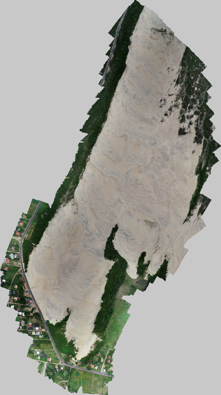
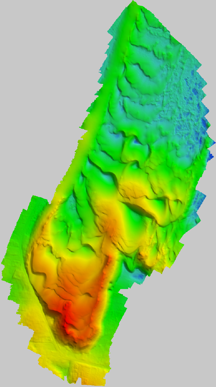
To map just 0.08 square kilometres of a dune system using a TLS took Grohmann et al. (2020) three days. Processing this data then took another three weeks since the many individual point clouds collected by the TLS had to be merged into one dataset.

The advantages of drone surveying

Drone surveying fills the niche between large scale remote-sensing (like aerial LiDAR) and on-ground surveying (like TLS). Rather than using LiDAR, drones use structure-from-motion photogrammetry to create digital elevation models (DEMs). 


Drone surveying measures much larger areas in a much smaller time frame than a TLS, but without the hefty price tag of aerial LiDAR. There’s also plenty of off-the-shelf software that can quickly process drone surveying data. Plus, because photogrammetry uses images to develop DEMs, the models come with useful visual context about what objects are, rather than just their 3D shape. 

  • Cheaper and more accessible than aerial LiDAR
  • Maps more area than TLS
  • Less fieldwork than TLS
  • Faster data processing
  • RGB images provide useful context for data

  • Covers less area than aerial LiDAR
  • Can’t measure elevation accurately when there’s lots of plant life
Drone Surveying data

When Grohmann et al. (2020) mapped the Garopaba Dune Field with a TLS, they also mapped it with drone surveying. Both the TLS dataset and drone dataset were similar in accuracy, but in just three hours, drone surveying mapped over 9 times the area mapped in 3 days with a TLS. The processing of the drone data took just 13 hours in comparison to three weeks for the TLS data. 

The only downside to drone surveying as a method to measure elevation is that it isn’t very accurate when land is covered by plants. This is because it uses photos to model elevation, and in plant covered areas the camera might rarely see the actual ground. LiDAR doesn’t have this issue since the pulses of light can pass through gaps in the vegetation, collecting information about the ground under the plants. 

Garopaba Dune Field, Brazil mapped by Grohmann et al. (2020). You can view the dataset on GeoNadir.

digital elevation model created by drone photogrammetry
Digital terrain model of the Garopaba Dune Field, Brazil

Learn more from datasets on GeoNadir

You can learn more about all kinds of places and ecosystems by checking out other datasets on GeoNadir. Datasets are uploaded from all over the world, and new datasets are uploaded daily, so there’s always something new to see!


Have your own drone surveying data tucked away on a hard drive somewhere? Upload it to GeoNadir so that other people can learn about the awesome work you’ve done!


References

Grohmann C.H., Garcia. G.P.B., Affonso, A.A., Albuquerque, R.W., 2020 – Aeolian dune modelling from airborne LiDAR, terrestrial LiDAR and Structure from Motion–Multi View Stereo. Computers & Geosciences, 143:104569 http://doi.org/10.1016/j.cageo.2020.104569

Subscribe for more stories from above, tips, & tricks

Share this article with your peers on social media.

Facebook
Twitter
LinkedIn
Topographic map with dots displaying data points of environmental drone mapping data. Three drone mapping overlays in different environments

Get a free account

  • Unlimited orthomosaics
  • Unlimited uploads
  • Free storage
Manage, process, analyze, and collaborate with your drone mapping data.