To set up a drone mapping capability for your organisation it is probably going to cost around $15,000-$20,000 in cash and time, by the time you have purchased the drone, completed some staff training, conducted initial fieldwork to collect data, and then established protocols.
So getting the right software to manage and analyse the mapping data you collect is essential. Getting the wrong software will mean that you don’t get the full return on investment from the expense you have gone through with the hardware and training.
There are some key considerations you have to make before you select the right software for your purposes.
What are some considerations for drone mapping software?
There is no shortage of drone mapping software out there. But there are a number of key considerations you need to make before you jump in. Getting your data processed into an orthomosaic is actually the simple part. But this is not where the value comes from.
Not every bit of software on the market provides you with the ability to process, manage, visualise, analyze, and share and collaborate your data. Some will only do a couple of these steps, a limited number will do them all.
Process
Taking the raw data that you captured with your drone and creating an orthomosaic, digital surface, and digital terrain models are the first step.
Every drone data processing software will do this part. But how intuitive and simple to set up this part of the process is varies widely across the software.
Some software needs coding expertise, others you need to know what adjustments to make to get the best outputs, and the most intuitive, like GeoNadir, it is as simple as dragging and dropping your raw data into a project.
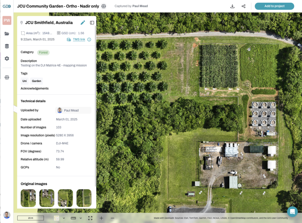
GeoNadir makes it simple and intuitive to upload your RGB, thermal, and multispectral raw data.
Manage
Drone mapping data can quickly take up TB of data. Your computer hard drive will quickly run out of storage space, and you will become overwhelmed with file management if you don’t have a robust plan. When you add on team members collecting data as well, then it becomes almost impossible to have a well managed data library.
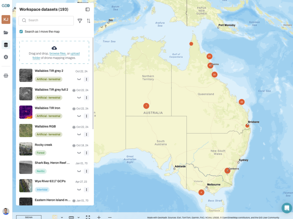
This is where GeoNadir excels. Our cloud-based storage means you never run out of storage space and can access your data from anywhere. You can also find your data easily in a team accessible workspace by just searching the global map.
Drone data is visual and spatial, so it makes sense to see it on a map, not a list!
Visualise
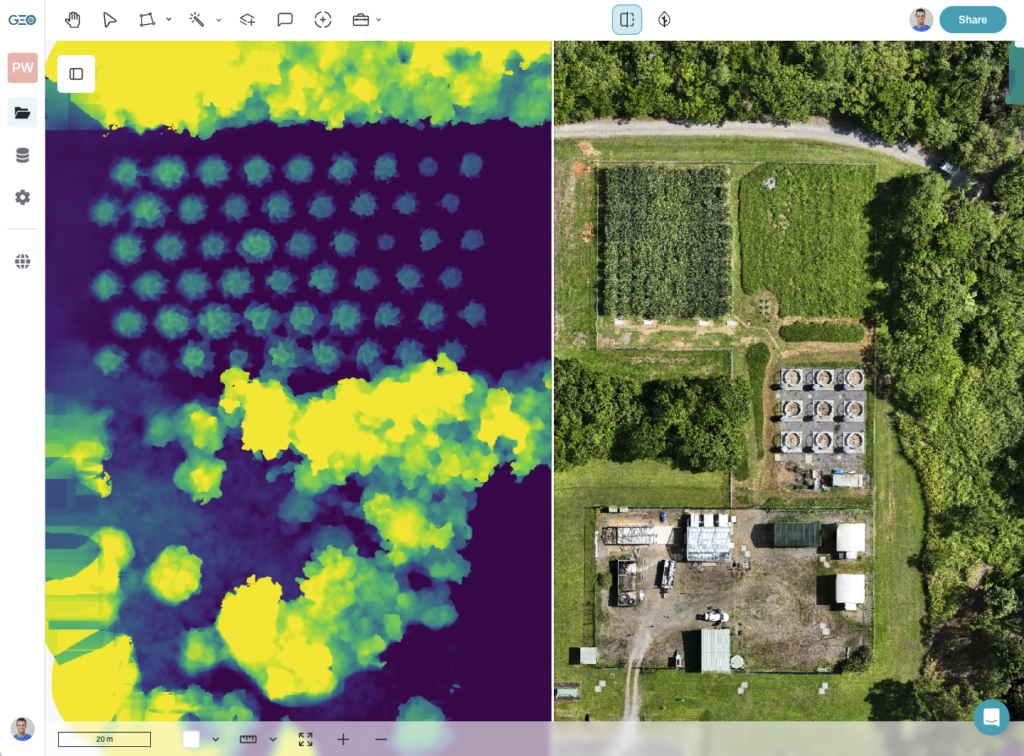
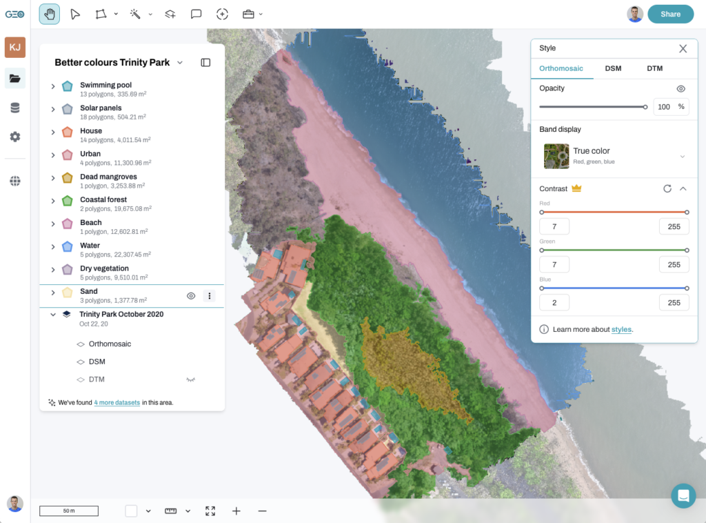
Being able to visualise your data once it has been processed is a key part to checking the data and making sure it has been processed correctly.
Having quick access to the orthomosaic, digital surface, and digital terrain models and then options to use them are essential.
Some software provides you with proprietary file types, or no visualisation options resulting in you having to use another software to open the files.
GeoNadir provides you with cloud-based visualisation tools, and the ability to download the outputs to geotiff file formats, or stream the orthomosaic to a GIS.
Analyze
You have spent thousands of $$ on buying a drone, hours conducting field work to collect the data, and now the most important part comes. Can you get the information from the data to create the insights you need, so decisions can be made?
Being able to measure, count, compare change over time, identify and quantify things are cruical parts of this analysis process. But, does the software allow you to do this easily, or do you need to bring in a GIS analyst to help you understand how the software works?
GeoNadir’s analysis tools are built to provide you with scientific-grade analysis, but with simple functionality that anyone can understand.
Share and collaborate
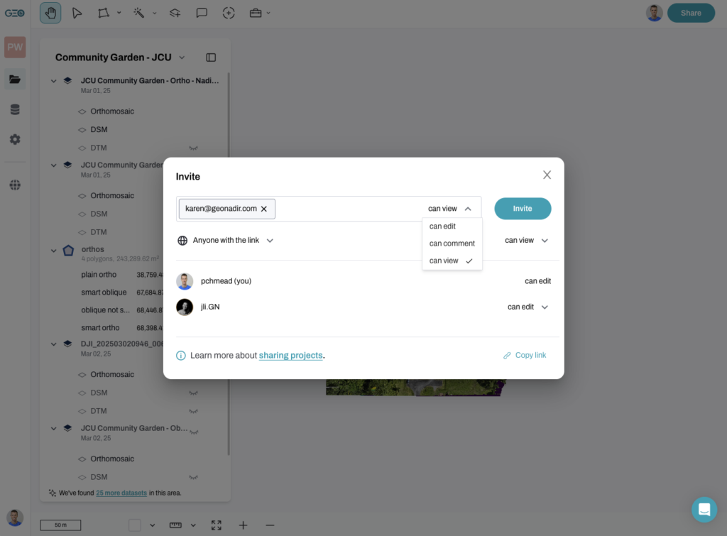
Working in a team and with stakeholders means that others need to contribute to this entire workflow. Whether it is adding in other data to the project, helping with data analysis, or simply viewing the insights you have created.
But, viewing spatial data can be challenging due to the large data files, file types that will only open in technical and clunky software like QGIS or ArcGIS, and require transferring data from one software to another.
GeoNadir makes it as simple to share your drone mapping data as it is a Google Doc. With a couple of clicks you have shared your data to a team mate and they are in the project seeing what you are seeing faster than a drone taking off!
Desktop or cloud based?
Now you understand the workflow your software needs to follow in order to make it simple to exploit your data, the next question is should I go for desktop or cloud-based software.
This might seem like a silly question in an age where cloud-based software is the norm. But there are a number of software providers that are still selling desktop software in this space.
Desktop software
Desktop software for drone mapping requires a dedicated high-end computer with a good graphics card and plenty of storage for all that data. This means spending another $5,000 plus.
Pros
- You can have all your data stored in house and not connected to the cloud.
- If you know what you are doing you can adjust processing parameters for the outputs.
- Processing times of the data can be fast depending on the quality of the computer.
- Can work offline in internet restricted areas.
Cons
- Data is stored locally and sharing is limited.
- Data analysis is limited to the single computer which limits team collaboration.
- Data processing can’t scale and this can cause processing bottlenecks at times of high throughput.
- Often requires a person to manage the process and data file management.
- If additional devices are needed to access the software then licencing costs can quickly escalate.
Desktop software can seem like a lower upfront cost, particularly if your organisation has a suitable computer already. But hidden costs such as staff time to manage the process and lost opportunities and efficiency for team collaboration significantly decrease the cost effectiveness.
Cloud-based software
Cloud-based software for drone mapping provides the ultimate flexibility for teams who want to easily collaborate, and work remotely or across multiple locations.
Pros
- You can access your data from any computer that has an internet connection.
- Data can be easily shared across the team and made available to other stakeholders.
- Data processing and storage can easily scale to meet the needs of the organisation as it increases flights.
- Multiple users can access the data at once.
Cons
- Access to the internet is required.
- Some costs can increase as usage increases, if the plan is not clear.
- Data security can be a concern if clear storage protocols are not adhered to by the provider.
Cloud-based software is often the right choice for organisations that have multiple sites, operate with remote teams, or want the ultimate flexibility with their data and the way they use and share it.
I want cloud-based software
There are many cloud-based drone mapping software out there, and we believe that the workflow described above – process, manage, visualise, analyse, share and collaborate – should be done all in one software. Otherwise shifting between software causes compatibility issues and a reduction in efficiency.
The next thing to consider is ease of use. Can your entire team use this tool, even the ones who are non GIS users? If not, then you are reducing the opportunity for valuable team members to provide input and guidance on the insights you are creating on this data.
Then cost – what is this going to cost you per year? Are there ‘hidden costs’ such as using confusing gigapixels pricing for data processing per dataset. Does the pricing scale for your team and the number of users you need inside a workspace?
The below list is a selection of the software we hear mentioned most commonly in forums and in our chats with our users. We have evaluated the software based on what is publically available on websites,
- WebODM Lightning
- Drone Deploy
- Site Scan (Esri)
- Propeller
- Maps Made Easy
- Pix4D Cloud
- GeoNadir
| WebODM Lightning | Drone Deploy | Site Scan (Esri) | Propeller | Maps Made Easy | Pix4D Cloud | GeoNadir | |
$3999 /year | $3999 /year | $3999 /year | $3999 /year | $3999 /year | $3999 /year | $3999 /year | |
| Process | yes | yes | yes | yes | yes | yes | yes |
| Manage | no | yes | yes | yes | no | yes | yes |
| Visualise | yes | yes | yes | yes | yes | yes | yes |
| Analyse | basic | yes | yes | yes | basic | yes | yes |
| Share and collaborate | yes | yes | yes | yes | public maps | yes | yes |
| GeoAI tools | no | yes | in ArcGIS | no | no | no | yes |
| RGB, thermal, multispec compatible | RGB, multispec | yes | yes | RGB | RGB | RGB | yes |
| Stream to GIS application | no | no | yes | no | no | no | yes |
| Scalable limits | no | yes | with Esri account | yes | no | yes | yes |
| Price / year USD | $420 | from $4,188 | Not stated | Not stated | $450 + gigapixels pricing | $2990 + gigapixels pricing | from $814 |
| Users per account | 1 | 1 | 1 | 1 | 1 | 1 | 5 |
| Use case suited for | broad | construction | broad | Mining and aggregates | broad | broad | broad |
| Ease of use | medium | medium | medium if familiar with ArcGIS | medium | simple | simple | simple | Buy Now | Buy Now | Buy Now | Buy Now | Buy Now | Buy Now | Buy Now |
If you are really set on using desktop software, then read our blog on the best desktop software here.
Summary of options
Each software you use has things you love and things you wish you could change. We have put together a bit of a summary of the common things we hear people talk about when comparing these software.
GeoNadir
GeoNadir is a collaborative GIS for environmental professionals to quantify ecosystem change.
What we love: GeoNadir is built for both technical and non-technical GIS users to easily collaborate on drone mapping data. It comes from a remote sensing and GIS foundation, so all the tools are built to create insights on your data fast, particularly with the geoAI tools for faster segmentation. The intuitive tools that support the workflow from data capture to insights make it simple for anyone to use.
To be aware of: GeoNadir is focused on nadir imagery and does not provide 3D models like some of the other software.
OpenDroneMap
“OpenDroneMap is a command line toolkit to generate maps, point clouds, 3D models and DEMs from drone, balloon or kite images”
What we love: This is an incredibly powerful open source application with an active and supportive community. WebODM Lightning is its cloud based product. There is an open-source desktop product too where users can maintain more control over processing parameters.
To be aware of: Getting started can be challenging if you are not well versed in coding, and the web application WebODM Lightning is an alternative for a less technical start. It also uses CPU rather than GPU for processing, so can be slow for large datasets. Tools for sharing and creating insights are limited. Processing limits apply for dataset sizes.
DroneDeploy
“DroneDeploy is reality capture software”
What we love: Drone Deploy has been in the market for many years and has developed sophisticated options to integrate data from various platforms and collection methods. This means that you can keep your ground surveys together with your aerial ones, and it will also store your drone videos. There are some interesting on-platform analytical options that are well suited to the built environment and mine sites. It is very much into the ‘digital twin’ space.
To be aware of: There are many features that you may not need but will still be paying for in your subscription. The entry price point is quite high, and if you add on additional users then it can become expensive very quickly. Users complain about the price of the software – it is priced for enterprise users.

Site Scan
“Site Scan for ArcGIS is the end-to-end cloud-based drone mapping software designed to revolutionize imagery data collection, processing, and analysis.”
What we love: Although it was developed by 3DR (aw, I’m nostalgic for the Solo), it was acquired more recently by Esri. This means that if you’re comfortable with Esri products, this will feel like a good fit and its well integrated with ArcGIS.
To be aware of: Being inside ArcGIS the learning curve can be steep for those not familiar with Esri products. This will limit collaboration and sharing across teams and with stakeholders. Pricing is not obvious – potentially only available with an Esri licence, so becomes expensive quickly.
Maps Made Easy
“Maps Made Easy is a web application that lets users upload aerial photos, stitch the images and host created maps.”
What we love: This is a simple interface generating all the standard photogrammety outputs, similar to DroneDeploy.
To be aware of: Free processing on freemium option is great, but results will be downscaled. Web maps will expire when subscription lapses. Complicated gigapixels pricing is used to calculate the cost of processing datasets – so whilst the upfront subscription might be cheap, it could cost considerably more in the long run.
Propeller
“Propeller empowers your team to map, measure, and manage their reality with survey-grade accuracy.”
What we love: Propeller is built for mining and aggregates users where knowing how big that hole is, or how much cut and fit you have is required to survey grade accuracy. Their hardware add-ons with their aeropoints and other sensors enable a high positional accuracy.
To be aware of: Their tools are very focused on the mining and aggregates industry, so if you are not in this space, then you may struggle to get the reports or insights you need from your drone mapping data. Pricing is also not stated on their website.
Pix4D Cloud
“Pix4D Cloud is the online platform for ground and drone mapping, progress tracking, and site documentation.”
What we love: Pix4D has been around for years and has both Pix4D Cloud and other desktop options. They are focused on the surveying and construction industry. Their tools are relatively simple to use.
To be aware of: They have seven different products that can process or use drone mapping data. Each one is built for different use cases. So it can get very confusing as to which one is right for you, and could get expensive if you need more than one to do the job you need.
What's your favourite cloud-based drone mapping software?
As with everything, there is no ‘one size fits all’ solution for online drone mapping software options. All the platforms listed above have some great features, and some quirks. So which is the best? Well that will come down to what you are looking for in terms of features and budget.
But at GeoNadir we believe that we provide the most complete end to end solution for drone mapping software, across processing, data management, visualisation, analysis, and sharing and collaborating on your data.
With our competitive pricing, we are also a well priced solution for small to medium businesses, through to having options to scale for larger enterprises and government clients.