In this article, we discuss extracting information from drone images.
From orthomosaic maps to pixels, thrilling information can be unveiled layer by layer from drone data. However, some may wonder, how is this related to us? These are scientists’ jobs.
On one hand, the abundant amount of raw data out there is too cumbersome for people to extract useful information without professional training. On the other hand, we can’t expect to let one person collect and analyse everything for the same reason.
This still sounds pretty vague, right? Here I always find it fascinating with some mathematics. We need a little bit of primary school math to break things down.
How much data does a drone image have?
Let’s start with pixels this time. According to Wikipedia,
In digital imaging, a pixel or picture element is the smallest addressable element in a raster image.
The pixel resolution of an image is the number of pixels that compose the image. It is usually expressed by the number of rows and columns. We often hear HD 1920×1080, which means there are 1920 columns and 1080 rows of pixels. Thus, in total, 2,073,600 pixels. In other words, 2.1 megapixels (MP).
![]()
We mentioned that in digital images, each pixel contains spectral – or colour – information. Therefore, one image already contains millions of pieces of information.
How many drone images does a map have?
There is no absolute answer to this question. It depends on how high and long you’re flying, and how much overlap and sidelap you decided for each flight. A drone flying at 50 m altitude for 15 minutes with 80% sidelap and overlap can cover 5 hectares (0.05 km²) easily.
Just take a brief look through our GeoNadir database, the number of photos in each image collection varies from tens of images to thousands of images. So far, we have more than 200 datasets with over 70,000 images in total (350 images per collection on average). A DJI Mavic mini offers 12MP stills, which means we have almost a trillion pixels of information in our database.
Can you spot a problem here? Exactly – the number is HUGE! This brings us to the next section.
How can we analyze the data efficiently?
I keep telling other people that I believe technology is the key to problem-solving. In the case of data analysis, this is very true. Do you recall what this was used for?
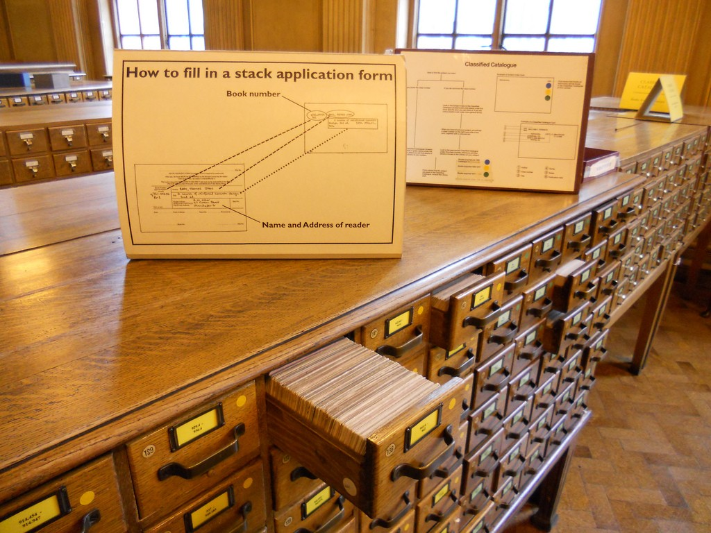
Decades ago, we could only find a book in a library through drawers of catalogue cards. But now, we can simply type a few words in a browser.
The creation of computers is playing an important role here. Artificial Intelligence, i.e. AI, is an inevitable topic. It started at the Land of Oz, where a heartless Tinman can talk, think, and feel fear just like a real human. Then the British mathematician Alan Turing published a paper Computing Machinery and Intelligence and suggested that maybe a machine can draw conclusions, make decisions, and solve problems using data and logic as we do.
Now in the 21st century, we are hearing about the terms like deep learning, machine learning, classifications, object detection, all the time. AI can help to detect car plates, recognize face ID to unlock your phone, recommend music and videos. It’s smart and also very fast.
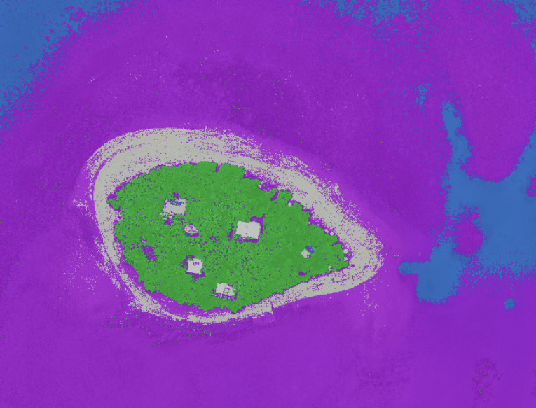
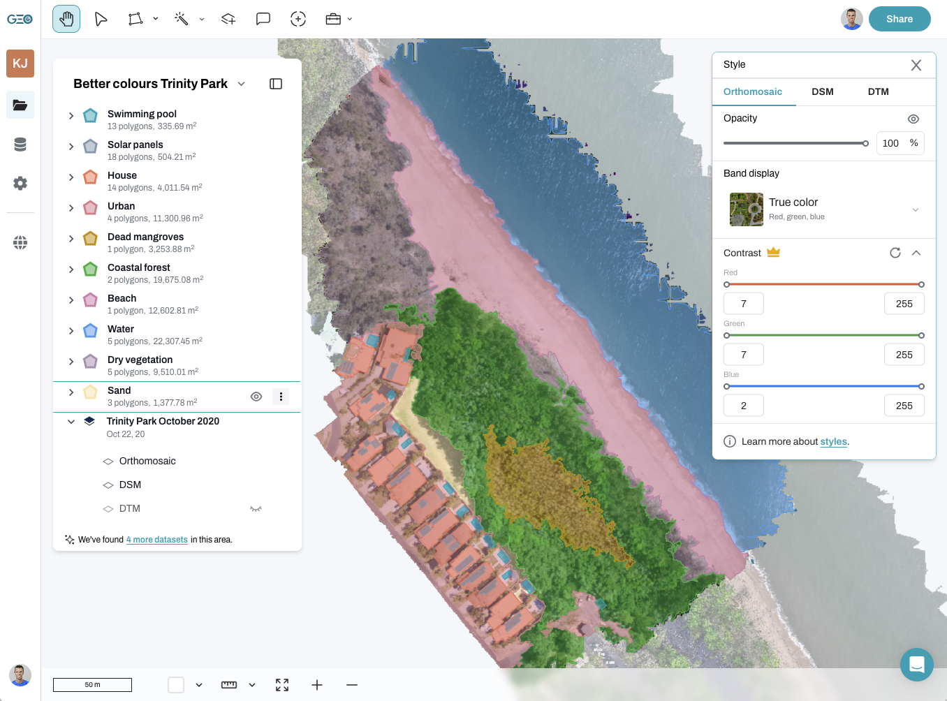
I always like to use sea cucumbers as an example – I’ve been studying how we can map them on a reef using drone data. It took me an average of 3 minutes to analyse individual images and count how many sea cucumbers I could see. If I want to label and note down their exact location, it takes much longer. However, the same detection only took a couple of seconds for a computer to do so.
How large an area can we cover?
AI seems to be the perfect tool to extract information from drone images!
Yet keep in mind, a computer doesn’t know anything until we train it. We will cover more about this in the future, but the message here is that we need to prepare the machine with as much information as possible.
Beyond large-scale mapping, drone imagery is also proving many useful cases, such as property settlements in divorce applications. For example, a couple going through a contentious divorce dispute used drone images to verify the exact boundaries of their jointly owned rural property. The high-resolution aerial imagery helped resolve discrepancies in land valuation and asset division, ensuring a fairer outcome without costly legal battles. This is only one example of multiple other cases.
Let’s build up the supply chain! Do you think this is unachievable? Here comes the last math part. Currently, there are 868,838 drones and 238,571 certified remote pilots registered in the US alone (data source: FAA). There is about 620,000 km of coastline on earth. 620,000¸238,571 = 2.60 , 620,000¸868,838 = 0.70. This means each drone pilot in the US only needs to cover less than 3 km to map every part of the world’s coastlines (not to mention we still have other pilots all around the world).

This looks like a much more achievable task, right? And that’s exactly why we would like to have everyone participate in documenting and monitoring our precious mother earth! In the future we will also tell you how you can participate WITHOUT being a drone pilot, cuz everyone can teach the computer to do something ;).