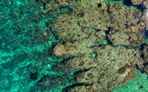
Author: Anne Crosby

Ecosystems

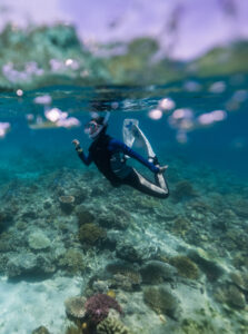
Hunting for soft corals in the coastal waters of NSW

When it comes to corals, the first image most people think of is something like the Great Barrier Reef. They think of big, colourful, rocky structures in warm tropical waters, teeming with all kinds of life. The hard corals that build these structures might be the most famous, but they’re not the only important coral

Read More »
Aerial view of a salt marsh from a drone
Drone Mapping Tips & Tricks

Salt marsh restoration tracking with drones

Coastal wetlands form a crucial connection between the land and sea. They provide protection from erosion, habitat for important fisheries species, and store large amounts of carbon. While mangroves might be the most well-known type of wetlands, other elements of these ecosystems are just as important for broader ecosystem health. Salt marshes are one important

Read More »
Praia Grande
Drone Mapping Tips & Tricks

Using drones for mapping litter and inspiring students

Drone datasets can offer lots of valuable information about the world around us. But while they help researchers and industry solve the problems of today, they’re also helping inspire the generations of tomorrow. Eduardo Werneck is a geography teacher at the Catarinense Federal Institute in Brazil. He’s using drones to help train his students to

Read More »
compass
Drone Mapping Tips & Tricks

Four ways to georeference your drone datasets

Drone mapping allows you to quickly collect detailed information about an area. But in many cases, the true value of this data is in its ability to be related to other geospatial data, like field observations, satellite imagery, or even other drone mapping datasets. To do this accurately, your drone dataset needs to be georeferenced

Read More »
Meet the team

Meet the GeoNadir team: Karen Joyce

Seeing the Great Barrier Reef is on many people’s bucket lists, but not many people have seen it from quite as many angles as Associate Professor Karen Joyce. Since the 90’s, she’s been using remote sensing to try and map the amount of live coral cover on the reef. In the past, she relied on

Read More »
Florida wetland
Drone Mapping Tips & Tricks

Mapping wetlands with drones and machine learning

Oftentimes, it is not until after an ecosystem or habitat has been degraded or lost that we realise the many services and benefits that it offered for free. Ecosystem restoration is one way that we can go about regaining these lost services. Wetlands are a valuable ecosystem that have been disproportionately affected by human activities.

Read More »
Drone Mapping Tips & Tricks

The value of recreational drone mapping

At GeoNadir, we’re all about seeing drone mapping data used to its full potential. Many of the datasets uploaded to GeoNadir have been mapped as part of targeted research projects. But that doesn’t mean they can’t provide useful information to answer other questions. Similarly, the datasets drone pilots collect recreationally can offer valuable insight, even

Read More »
Nova Scotia Coastal Erosion
Drone Mapping Tips & Tricks

Measuring coastal erosion in Nova Scotia, Canada

Who wouldn’t want a house with an ocean view? But for people in Nova Scotia, building a house on the waterfront can be riskier than many homeowners might realise. Coastal erosion is steadily chewing away at Nova Scotia’s coastline, placing homes and infrastructure at risk of washing away.  The Applied Geomatics Research Group at Nova Scotia Community

Read More »
Rocky shore, Crete
Case Studies

Mapping the bathymetry of the Mediterranean

When most people think of the ocean, they think mostly of water, not the land that lies underneath it. But bathymetry, which is the study of water depth, is critical for understanding our coastlines. Water depth influences currents, waves, and where different marine life can live. Like topography on land, drone mapping can help collect

Read More »
Joan diving
Meet the team

Meet our Earth Observation Data Scientist: Joan Li

As a relatively new technology, it’s common for people to come to the world of drones from different backgrounds. For Joan Li, drones and deep learning gave her the chance to explore her passion for marine science when the pandemic meant she could no longer observe it from below the water.  As the Earth Observation

Read More »
Turtle tracks
Case Studies

Green Sea Turtle Conservation | How can drones help?

Currently, drones are helping with green sea turtle conservation. Drones can map their nesting beaches to help monitor threats and local populations. Green sea turtles are an iconic species, found globally in subtropical and tropical oceans. They play an important role in maintaining the health of seagrass ecosystems and all the organisms seagrasses support. Like many

Read More »
Data management
Drone Mapping Tips & Tricks

Drone Data Management (Simple to use)

At GeoNadir, we want to see drone mapping data used to its full potential. Here you will find information about our drone data management software and more.   As drone technology evolves, the fields and industries where drone mapping data can provide valuable insights continues to grow. But as we collectively gather more and more

Read More »
Wildlife damage in sunflower field
Drone Mapping Tips & Tricks

How drones are helping farmers map wildlife damage

When drones first started gaining attention, they weren’t very accessible or useful for people without a technical background. It’s no surprise then, that until recently, drone mapping has mostly been the domain of universities, governments, or large companies. But as the technology has matured, drones and data processing software have become more accessible and affordable.

Read More »
Case Studies

Monitoring savannah ecosystem restoration with drones

Ecosystem restoration is a key element of repairing damage to the planet and working towards a sustainable future. In theory, ecosystem restoration is simple. You simply regrow damaged or lost habitat. Saying this and doing it however, are two very different things. Ecosystem restoration is still a very new, often poorly understood science. It is

Read More »
Environmental monitoring Gudai-Darri bat caves
Case Studies

Drone environmental monitoring: The benefits of perspective

Creating a sustainable future is a tricky balancing act of causing the smallest environmental impact for the largest positive outcome. Knowing the environmental impact of an activity, and mitigating the impact, depends heavily on good environmental monitoring. Drones are quickly becoming an indispensable tool in this space. Drone environmental monitoring offers a fast, cost effective,

Read More »
drone mapping imagery of urban wetland
Drone Mapping Tips & Tricks

What is drone mapping?

Part of what makes drones such a valuable technology is their ability to collect large volumes of data. While drones can collect data in many different ways, one of the most widespread methods is drone mapping. From real estate, to environmental science to mining, drone mapping has been a game changer and as technology advances,

Read More »
Drone imagery of seagrass meadows off Curtis Island
Artificial Intelligence

Mapping seagrass with machine learning and drones

Getting an understanding of the size and scope of marine ecosystems has always been a challenge for environmental scientists. Seagrass is no exception. These intertidal and subtidal meadows help support important fisheries species and iconic animals like dugongs. They’re also increasingly under threat from things like poor water quality. But with some meadows being many

Read More »
Landsat OLI satellite image of fire in Yosemite National Park
Case Studies

Satellite imagery and drones: Understanding fires and floods

In the past, satellite imagery has been one of the main methods of data collection for remote sensing. As drone technology continues to advance, drones have begun to challenge satellites as a significant data collection method in many fields. Each method has its own unique advantages and disadvantages. But the combination of the two technologies

Read More »
drone image over the great barrier reef
Case Studies

Using drones and precision agriculture to protect the reef

Precision agriculture is an increasingly popular farm management strategy used to improve farm sustainability. It aims to facilitate adaptive farm and crop management based on crop health data.  By only applying treatments when needed, farmers can reduce the amount of environmentally damaging chemicals, like pesticides, used on their crops, and improve water and soil health. Advancing

Read More »
ocean beach and rock from a drone
Case Studies

Geological mapping with drones

Most people don’t put a lot of thought into what makes up the ground that we build, work, and live on. But we can learn a lot from geology. Rocks hold the multi-billion-year-old history of the planet we live on, influence where we can grow food and live, and much more. But deciphering and interpreting

Read More »